Customer stories
Here you find our costumer user stories where the use and benefits of systems and components of the geo-konzept GmbH are described.
Here you find our costumer user stories where the use and benefits of systems and components of the geo-konzept GmbH are described.
„In addition the economic advantage by saving resources, the complete documentation, which can be integrated seamlessly into the workflow, is the great advantage of this solution!”
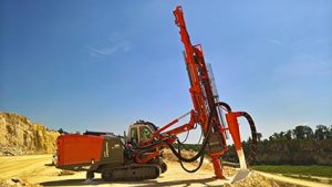 Mr. Peter Schröppel, a driller and blaster of Märker Zement Harburg, is convinced that the blasting operations in their quarries would not be possible without geo-konzept’s drilling and blast design solutions!
The company Märker Zement in Harburg uses our automatic 3d measurement system together with the software QuarryX, which provides various tools and analysis possibilities for the planning of the drill pattern for precise and safe blasting. In real time, parameters such as drill angle, depth, drilling direction, subdrill and the desired burden can be optimized and adjusted. The precise and accurate alignment and drilling of the holes is then carried out by our drill rig solution RiGuide, which aids the driller with correctly setting up the mast in angle and direction as well as finding the collaring position. “Due 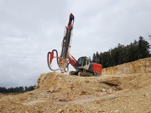 to the precise drilling lengths we need less explosives and save on drilling costs. In addition, RiGuide guides our driller exactly to the hole collar position, which saves us from staking out the drill holes on the drilling area and therefore saves additional time” explains Schröppel. After the drilling work is completed, the recorded data is transferred back to the blast design software QuarryX and integrated there. Thus, the data of the drilling as well as geology are completely documented. Schröppel further states “In addition the economic advantage by saving resources, the complete documentation, which can be integrated seamlessly into the workflow, is the great advantage of this solution!”
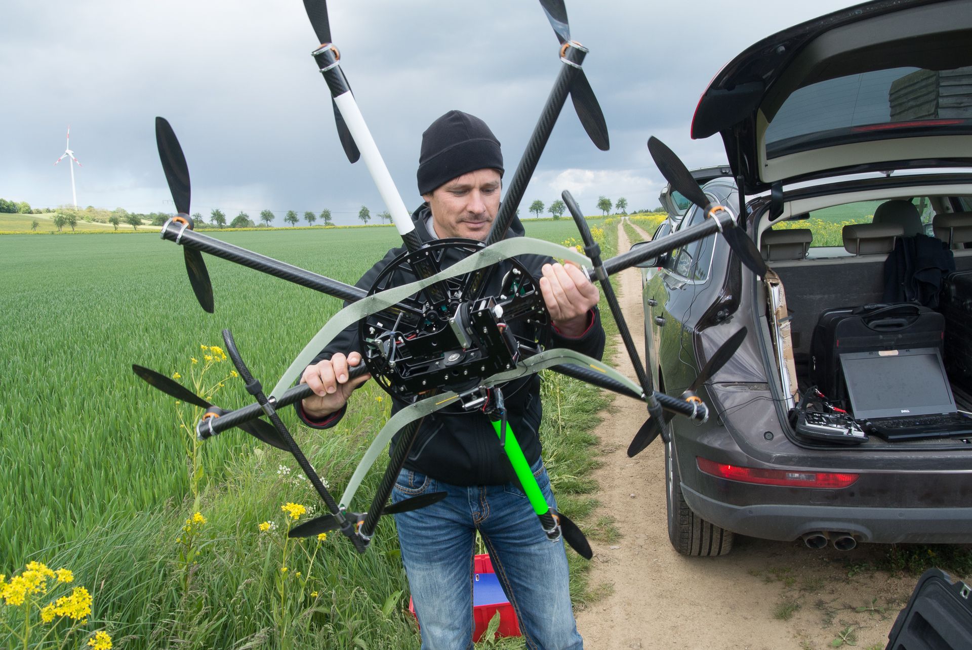
Civil UAV systems are not unusual in agriculture anymore. The lightweight and ultra-modern flight platforms are used for many different applications. For this purpose geo-konzept offers its XR6 hexacopter, a versatile platform, as an ideal combination to the in-house software solutions. The XR6 bundle contains all relevant components as well as a multiday training by our product specialists.
 Biomass evaluation
Equipped with the multispectral cameras of Tetracam, the XR6 provides area-wide data for calculating different vegetation indices like REIP, NDVI or SAVI. These enable an easy, comprehensive and fast scoring of crop and can be included in the crop farming consultancy.
Especially in seed breeding, special data like crop height or beginning of flowering of different cultures can be exactly determined. The UAV technique is here linked with geo-konzept’s software for parcel planning and evaluation.
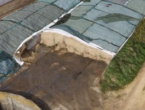 Volume determination of silo installations
The calculation of the exact volume of silo installations or other piles never has been so simple, fast and exact. The UAV system acquires the dimension with millions of image survey points from the air within a few minutes.
After a short processing time, the high-precise 3D model is available and the in-house software VolumeX provides you with the survey report – ideal for the regular documentation of feedstock reserve for production plants or during volume based accounting of different material.
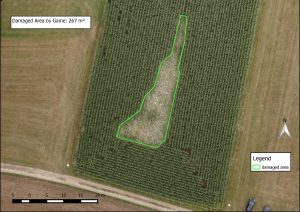 Evaluation of damage and weed management
The aerial view enables an easy evaluation of damage caused by game or hail. As a “flying eye”, the XR6 can be used as an ideal tool for consultants and insurances. The images are immediately available and offer a detailed resolution: Hence they facilitate an objective evaluation and enable new applications like area-specific weed treatment.
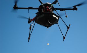 Biological pest control
The XR6 dropper is our new tool for a facilitated biological pest treatment. To make an automatic output of ichneumon as efficient and reliable as possible, geo-konzept developed together with partners its own optimized dropper.
The container with the ichneumon clutches and the dropper are mounted to the XR6 hexacopter. After take-off, the XR6 flies automatically the treatment area and drops spheres with the beneficial animals in regular intervals that are GPS triggered. The treatment is controlled and documented. The exact dropping facilitates the documentation, saves expensive working time and ensures the success of the biological treatment action.
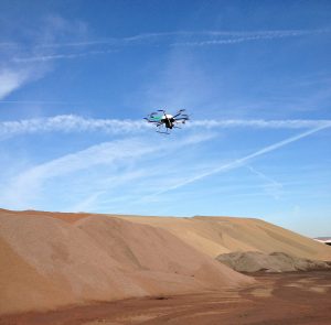
Silently a small dot buzzes over the expanded clay plant of Liapor in the Franconian Hallerndorf. Like it would follow an invisible line at the sky, it moves on its predefined paths over the different huge piles. Suddenly it veers and flies diagonal to the former track towards the boundary of the industrial plant. Here Udo Hack is standing. In front of his stomach, he has a remote control. But his hands at the small joy-sticks do nothing: “At the moment the autopilot does the whole control”, tells the mineralogist and looks concentrated to the growing bigger point. In the meanwhile eight arms with rotor blades are clearly visible. For a short moment, the flight platform stops in the air, then Hack takes the control. A few careful stick movements later, the arachnoid device stand silently at the ground in front of us and the remote control friendly tells us “Motors off”.
“The take-off is an adventure every time I steeply lift the octocopter to handle it over to the autopilot in approximately 20m height. The landing is, with a little bit of exercise, no problem” says Udo Hack and picks the light device of 5 kg at one of its carbon arms. He points to the camera at the bottom side. During the ten minutes flight, it has taken hundreds of images; each stock-pile has been photographed several times from different directions, also fully automatically. Hack now will stitch the images to a mosaic at his office PC. Beside the classical orthophoto, an accurate 3D elevation model is created. The last is the base for the volume calculation with the software VolumeX. It is part of the portfolio of the mining expert geo-konzept, which also offers the geo-X8000. Beside the exact calculation of available material for the economic documentation and planning, Liapor improves the working safety on its ground by using the civil drone. Whereas previously the survey had to be done in-between machines and trucks, Udo Hack and his colleagues stay in safe distance now.
Increased safety had also been the reason for the UK company QuarryDesign and its head Adrian Wilkinson that had one of the first customers of geo-konzept, to order a geo-X8000. QuarryDesign is a specialist in the survey of whole quarries. Since many years, they are using terrestrial laser scanners. Now more frequently the UAV (Unmanned Aerial Vehicle) is used. “The gain of time is simply enormous and the data quality is extraordinary”, as the enthusiastic company head explains. Together with the fitting geo-konzept software QuarryManager, the results of the flights get useful for the site manager: as three-dimensional quarry layout with all details.
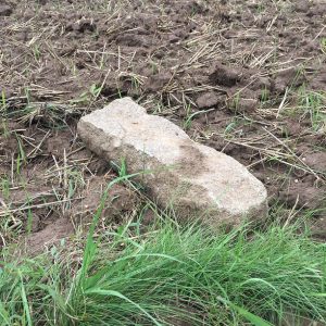 Ein Gang über die Fluren zeigt, dass durch die Bodenbearbeitung von Zeit zu Zeit Grenzsteine bewegt und zu Tage gefördert werden. Ein direktes Nachvollziehen der Flächengrenzen anhand der Grenzsteine ist dann nicht mehr möglich. Sollen die Grenzen wiederhergestellt werden, wird ein System mit höchstem Genauigkeitsanspruch benötigt. Das GNSS-Survey-Plus-Paket bietet Ihnen all das und besteht aus Empfänger,Handrechner, Software und Korrekturdaten.
Praxis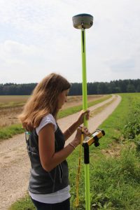
Ein Praxistest zeigt, dass es mit den Grenzsteindaten vom Amt möglich ist, die Punkte ohne Umstände an zu navigieren. Dazu müssen zuerst die Daten auf den Handrechner übertragen werden. Mit Hilfe der Vermessungssoftware können diese dann angezeigt werden. Die Navigationsfunktion der Software hilft durch Angabe von Richtung und Entfernung beim Anlaufen der einzelnen Grenzsteine. Damit dies mit der nötigen Genauigkeit geschieht, errechnet der Empfänger Stonex S9i mit Hilfe von Korrekturdaten die exakte Position. Für die allerletzte Positionierungsgenauigkeit hilft ein Lotstab mit integrierter Libelle, an dem auch Empfänger und Handrechner befestigt sind. Durch das Ausstecken der Grenzsteine wird der damit einhergehenden Verlauf der Flächengrenze sichtbar.
Hinweis
Im Vorfeld sollte durch die Beteiligten geklärt werden, ob eine derartige Vermessung für alle Beteiligten in Ordnung ist. Ein öffentlich bestellter Vermessungsingenieur ist dann nötig, wenn das Ganze rechtlich belastbar sein muss und sich die Nachbarsparteien nicht einigen können.

