Drilling and blasting:
Hard- & software solutions for your quarry

Fly rock, poor fragmentation, vibrations – we help you to minimize fundamental problems in the drilling and blasting process. Carry out blasts safely and efficiently! No more usage of tape measures, no more time-consuming, manual geometric calculations: we bring digitalization, precision, safety and time savings to your quarry.

Highend systems, user-friendly software and our experts‘ many years of know-how facilitate the entire drill and blast process: surveying the rock face, stake-out of planned hole positions using GNSS with centimeter precision to planning the ignition and explosives as well as documentation and data analysis.

OUR SOLUTIONS – FROM PLANNING TO DOCUMENTATION:

Innovative, modular system solutions including 3D surveying of the rock face and planning of the drill pattern, through drilling the boreholes using GNSS-supported 3D drill rig control, to borehole measurement and planning of ignition and explosives. The product portfolio is supplemented by software solutions for calculating volumes of stockpiles and pits as well as managing the digital twin of your quarry.

With our high-precision 3D scanner, areas of the rockface are scanned fully automatically and a real-time 3D model is created that enables immediate control of the measurement. The measurement process for an average rockface usually takes no longer than 10 minutes and delivers repeatable, highly accurate results. For areas that are difficult to access, we offer an equally precise drone system with centimeter-accurate location.
Our self-developed, award-winning QuarryX software with a clear user interface in twelve languages ​​can process rockface, borehole and survey data from all common systems, regardless of the manufacturer. From project-related master data management to blast design and ignition scheme planning: numerous tools support the authorized blasting operator in his daily work.
From now on, you can stake out the boreholes with the highest level of precision using GNSS. Our QuarryPocket GPS software will guide you reliably to the planned points, including automatic height and position correction as well as real-time control via live profile view: move the borehole and always have your specifications in view. No more tape measure and measuring stick!
Implement even the most complex plans directly with the drilling rig: with the 3D borehole navigation system RiGuide, the points are precisely controlled and the direction, angle and depth are implemented exactly. No more manual marking! Automatic adjustment of length, position and angle, documentation of all important parameters. The return transfer of the collected data updates the planning model to the actual state.
With the borehole measurement system, you receive all the data you need for safe blastings: precisely probe the borehole path, deviations are displayed in real time. Combine the data with the rockface model, with the default calculations being updated automatically. A realistic model of the blasting field with the actual paths, specifications and lengths of all boreholes.
Create suitable ignition plans and loading schemes based on planning data! Databases with all common explosives and detonators; insertion of surface retarders between the boreholes with a mouse click; automatic calculation of the ignition time for each detonator; digital simulation of the ignition system including checking for overlaps; exact calculation of the explosive use for each borehole.
Full control over all processes: Surveying and planning data is available to everyone involved in real time. Do borehole parameters and planning data match? How do deviations affect the specifications? Do you need to react by changing the charging station? The analysis and documentation tools for quality assurance and control provide a solid and reliable basis for your decisions.
In addition to our extensive support (on-site & remote), we also regularly offer individual training courses for software and hardware. Our workshops offer the perfect platform for exchanging experiences, imparting knowledge, training and refreshing knowledge. Optimize your workflows and get the most out of our systems! Benefit from the experience and know-how of our experts.

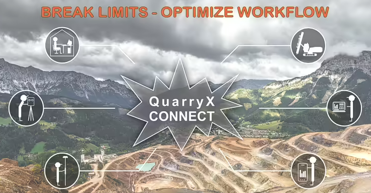
QuarryX Connect: Connect all steps and participants!

With QuarryX Connect, all workflow steps and involved people in the quarry are now networked with one another: no more USB sticks, no more paper drilling plans! Send drilling plans wirelessly directly to the drilling rig –  the actual holes drilled and additional information are also transmitted. Drilling and blasting are thus even more closely interlinked to enable seamless data transfer and data evaluation. Further evaluation of drilling and blasting work (KPIs, such as costs/ton, drilling meters/ton) is also simplified by the central data storage and synchronization of the data in QuarryX Connect.

  DID YOU ALREADY KNOW…

… that geo-konzept is one of the only companies in the world whose mining and blast design systems run on ALL continents of the planet? Our solutions are even successfully used in the Arctic. The world relies on geo-konzept. You can too.

GET ADVICE NOW!

    Your data:


    I consent to the further processing of my data within the framework of the conditions stated in the data protection regulation for the purpose of contacting me. This page is protected by reCAPTCHA. Google's privacy policy and terms of use apply.

    Always stay up to date: subscribe now for our free NEWSLETTER!