For many years, geo-konzept GmbH has been actively involved in both national and international research projects. In collaboration with international partners from research and industry, we work on pioneering technologies, equipment, and software. Our expertise in high-precision satellite positioning data, parallel guidance, GIS, blast design and data processing is particularly valuable in this work.
Below you will find our current and past research projects:
CURRENT RESEARCH PROJECTS
BoDi --- Optimized fertilization management via soil sensors
Project: Soil Sensor-Based Optimized Fertilizer Management as an Interoperable Agricultural Service
Project Duration: January 2025 – December 2029
Project Partners: AG Wesenberg, AG Trebbin, Landwirtschaft Petra Philipp, Fürstenwalder Agrarprodukte GmbH, Landwirtschaftliche Beratung der Agrarverbände Brandenburg GmbH, Bodenprobetechnik Peters GmbH, VisDat geodatentechnologie GmbH, Leibniz-Institut für Gemüse- und Zierpflanzenbau Großbeeren, Hochschule für Nachhaltige Entwicklung Eberswalde, geo-konzept GmbH
Funding Program: Within the framework of the Europäischen Innovationspartnerschaft (EIP-AGRI) through the Europäischen Landwirtschaftsfonds for Entwicklung des Ländlichen Raums (ELER) (EAFRD) and the State of Brandenburg
Brandenburg’s agriculture is characterized by highly heterogeneous locations and climatic challenges, making it particularly dependent on innovative approaches in precision farming. However, precise site information and climate-adapted fertilizer requirement models are lacking. This project develops a software package for determining fertilizer requirements by incorporating remote sensing and weather data, as well as soil moisture. It includes new functions for precise humus determination and evaluation. A sensor prototype for texture mapping is being functionally enhanced and developed into a working model. A new workflow for soil sampling avoids media breaks and information loss. A cloud-based IT system environment ensures the interaction of all components with operational systems and a new data processing application. Efficient nutrient management helps Brandenburg increase yields, reduce costs, and minimize nutrient losses.


ISObot --- Optimized management of field robots
Project: Optimized Management of Field Robots through Intelligent Process Control and Standardized Interoperability Mechanisms
Project Duration: January 2025 – October 2027
Project Partners: Geisenheim University (HGU), Wille Engineering
Associated Partners: Bayerische Landesanstalt für Landwirtschaft (LfL), Agreenculture, Agrointelli, Hessische Staatsweingüter GmbH Kloster Eberbach
Funding Program: BMEL Interoperabilität in der Landwirtschaft / Projektträger BLE
Autonomous field robots have enormous potential for making crop production more sustainable and mitigating the shortage of skilled workers. Although these systems are now market-ready, significant challenges remain, particularly regarding their integration with machine management, process control, and the interaction between the robot and the implement. The ISObot research project aims to optimize the management of field robots through improved interoperability at various levels and automated process control. The starting point is commercially available robot-implement combinations and a web-based telemetry system. For a specific application in weed control in viticulture, a process control system is being developed that uses sensors and intelligent algorithms to monitor the work process, actively control it, and document the quality of work.
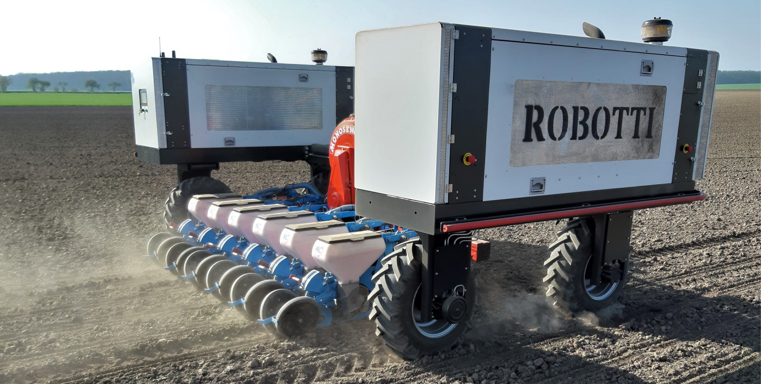
Communication between the robot and the implement for controlling various parameters will take place via ISOBUS. Another application in arable farming will focus on monitoring the weeding process and recording process parameters. In both cases, the systems will be linked to a web-based application to exchange process data and recorded parameters in real time, in accordance with the ISO 11783 standard. The application will be integrated into the machine management system to visualize process-relevant information via user-friendly interfaces and make it available for further agronomic use. Dissemination and transfer activities will be used to facilitate exchange with agricultural practitioners. Furthermore, the integration potential of this approach into industry-wide efforts to improve the interoperability of electronic communication in agricultural technology will be evaluated. Finally, recommendations for further standardization efforts should also be derived.
ADVENT --- Increasing N utilization efficiency
Project: Adapting fertilization to variations in yield potential and nutrient supply in sub-areas
Project duration: October 2024 – November 2027
Project partners: Christian-Albrechts-Universität Kiel, Landwirtschaftliches Technologiezentrum Augustenberg (LTZ), Landesbetrieb Landwirtschaft Hessen (LLH), ISIP e.V.
Funding program: BMEL Innovationsförderung / Projektträger BLE
The aim of this research project is to contribute to increasing nitrogen use efficiency and thus to climate and groundwater protection in arable farming. To this end, new, model-based algorithms will be developed to enable demand-based, site-specific calculation of nitrogen fertilization for winter wheat, taking into account differences in site-specific yield and nitrogen mineralization potential, as well as current weather conditions. Furthermore, these site-specific fertilization algorithms for winter wheat, along with an existing site-specific fertilization algorithm for winter rapeseed, will be implemented in practical IT solutions using various data sources.
We expect this to result in savings of approximately 10–15% in the amount of nitrogen applied, while simultaneously increasing yield and quality with a limited overall nitrogen supply. At the same time, it can be assumed that the improved availability of agronomically validated fertilization algorithms will lead to a wider adoption of sensor-based, site-specific nitrogen fertilization. The integration of novel, commercially available sensor systems and collaboration with service platform providers established in both the data collection and marketing of sensor products and in fertilizer consulting (www.isip.de, geo-konzept) will make a concrete contribution to increasing nitrogen efficiency.
AutoDGB --- Automation in UAV rating
Project: Development of an automated solution for drone-based field trial assessment
Project duration: October 2019 – May 2025
Project partners: Hochschule Weihenstephan-Triesdorf, Technische Universität München, Saatzucht Josef Breun GmbH & Co. KG, geo-konzept GmbH
Funding program: BMEL-Innovationsförderung – Züchtung leistungsstarker Weizensorten im Zeichen des Klimawandels / Projektträger BLE
Crop production is facing increasing pressure due to population growth, climate change, and societal demands for more environmentally friendly agriculture. This is particularly true because the sub-goals of “higher yields,” “optimized product quality,” and “adaptation to changing production conditions (climate, societal requirements)” are sometimes in conflict with one another.
Breeding is one method that can be used to optimize production with regard to the aforementioned requirements. This is especially true for adapting to the increasing variability of precipitation associated with climate change (heavy rainfall, longer periods of drought), as well as for breeding for resistance to plant diseases and the potential reduction in pesticide use that this may entail.
Breeding progress is directly related to the amount of initial variability generated through crossbreeding and, consequently, the number of field trials conducted to select breeding lines. Simultaneously, the effort required for assessment and laboratory analysis increases with the number of trials. The visual evaluation of plant stands (assessment) and the collection and analysis of samples provide the crucial basis for subsequent selection. However, assessments are often subjective and prone to human error. Currently, breeding progress is largely limited by the scarcity of human labor in the field and in the laboratory.
The increasing developments and research in sensor-based phenotyping offer a growing number of possibilities for reliably and objectively recording plant or stand characteristics in a non-destructive manner, both qualitatively and quantitatively. Furthermore, previous studies indicate that individual sensors (multispectral) can simultaneously capture several traits.
The use of UAVs (Unmanned Aerial Vehicles) is particularly noteworthy in this context. UAVs can be used to survey crop stands with various sensors, such as multi- and hyperspectral cameras, laser cameras, and thermal cameras, quickly and frequently. However, the subsequent processing of the data (compositing, rectifying, georeferencing, and assigning it to individual plots) currently requires specialized qualifications and is very time-consuming. At present, no practical solution is available on the market that would enable the independent collection and analysis of sensor-based data. This is primarily due to the existing automation gap between data acquisition and processing. The main objective of this project is therefore to close this gap and develop a practical, largely automated, and optimized solution for the application of drone-based assessment in wheat breeding.
SNaPwürZ --- Digital Innovation in On-Farm Research and Precision Experiments
Project: Smart, sustainable, precise, repeatable, transferable, and resilient – Agriculture under changing future conditions – Opportunities through digital innovation in on-farm research and precise field trials
Project duration: July 2023 – June 2026
Project partners: FH Kiel – Agrarwirtschaft, EXAgT GmbH, AgDoIt GmbH, geo-konzept GmbH
Funding program: EIP-Agri Schleswig-Holstein
This is about a digital toolbox that enables every farmer and consultant to address and analyze relevant questions at their own location and with their own machinery.
For partners in the upstream and downstream sectors, this offers the opportunity to collect more data together with farmers and better address practical issues. At the same time, these surveys are designed to meet all official quality standards so that they can also be used in research and product development. Furthermore, this information will provide a foundation for better supporting and evaluating business decisions in a changing environment.
Alongside the operational group, an expert advisory board will be convened to provide advice and support on substantive issues. This board will consist of, among others, advisory institutions with their own experimental facilities (Chamber of Agriculture), private consulting firms (e.g., Hanse Agro, GBB), experimental sites (e.g., university experimental farms), and technology providers (e.g., Haldrup, Wintersteiger).
SCHEBA² --- Highly intelligent single plant assessment
Project: System for Chronological Highly Intelligent Individual Plant Assessment with Application Recommendations in Agriculture
Project duration: 01/2024 – 12/2025
Project partners: digital workbench GmbH, geo-konzept GmbH
Project sponsor: VDI/VDE Technik und Innovation GmbH
Funding program: Bayerisches Verbundforschungsprogramm (BayVFP) des Freistaates Bayern Förderlinie “Digitalisierung”
The goal of the SCHEBA² project is to develop an autonomous platform for monitoring individual plants in arable and vegetable farming. This platform utilizes image processing/AI to recognize and assess the condition of crops (primarily vegetables) with regard to factors such as biomass, diseases, and water requirements.
Based on this analysis, each individual plant within a crop can be selectively supplied with the precise amount of resources it requires.
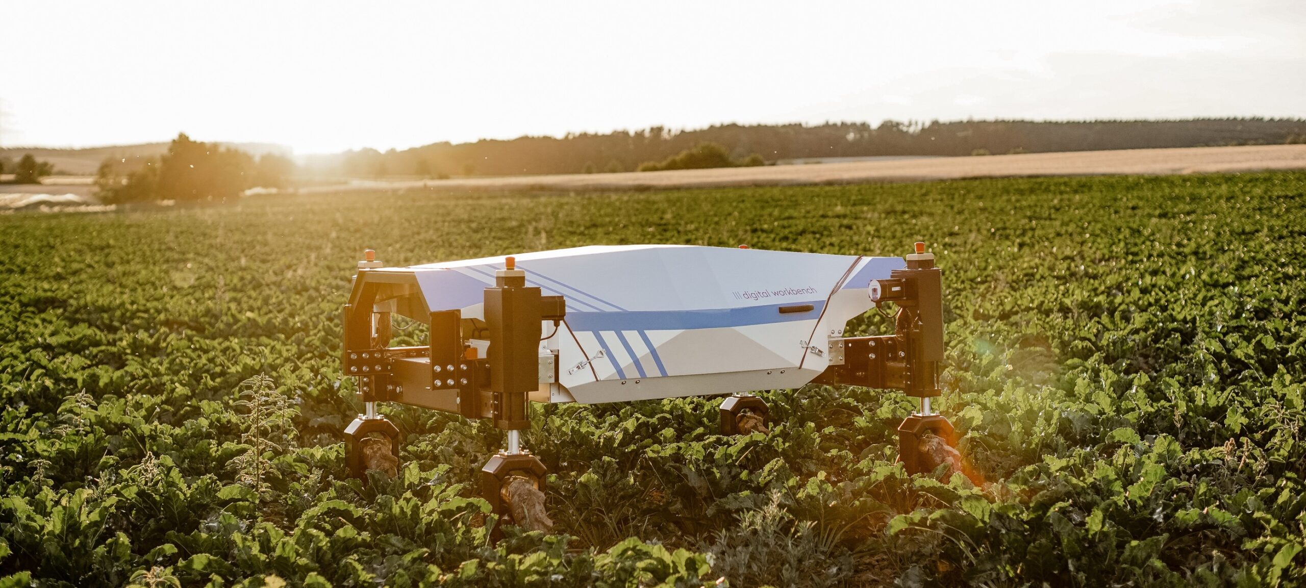
In addition, the collected data will make it possible to distinguish between plants and weeds in the respective plant rows, so that selective, chemical-free weed control can be carried out in a further step.
FINISHED RESEARCH PROJECTS
SuperNav --- Precise positioning of forestry machines
Project: Submeter positioning in forestry under challenging SAT/NAV conditions
Project duration: November 2020 – January 2024
Project partners: FVA Forstliche Versuchs- und Forschungsanstalt Baden-Württemberg, Fraunhofer Institut für integrierte Schaltungen, HSM Hohenloher Spezial-Maschinenbau GmbH & Co. KG, geo-konzept GmbH
Funding program: BMEL / Projektträger FNR
Precise positioning of forestry machinery is fundamental for sustainable, soil-conserving, and efficient timber harvesting. However, reliable sub-meter positioning in real time within forest stands is not possible with currently available Global Navigation Satellite Systems (GNSS) receivers. The project aims to develop and field-test technical systems that compensate for the unfavorable conditions prevalent in forests for satellite positioning, such as shadowing, diffraction, and a poor signal-to-noise ratio, through innovative GNSS antenna technology and achieve higher accuracy through supplementary sensor fusion. The technologies to be developed within this project will ensure consistent, real-time positioning accuracy in the sub-meter range.
MoniQua --- Disease monitoring in orchards
Project: Development of a digital monitoring system for quarantine diseases in orchards and fruit breeding
Duration: March 2021 – May 2024
Project partners: JKI Züchtungsforschung an Obst Dresden-Pillnitz, Leibniz-Institut für Agrartechnik und Bioökonomie Potsdam e.V. (ATB), geo-konzept GmbH
Funding program: BMEL-Innovationsförderung Pflanzengesundheit / Projektträger BLE
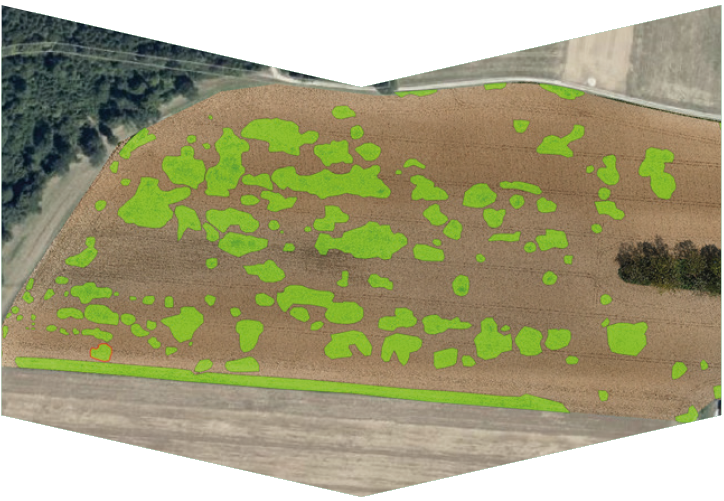
The aim of this project is to establish a digital monitoring system for the early detection and localization of quarantine diseases in commercial fruit growing. Based on image capture and machine learning image processing algorithms, species-specific disease symptoms will be recorded and mapped in large numbers, at various developmental stages, and with high spatial resolution in apple and pear orchards. The initial focus is on the detection of leaf symptoms. Data on the progression of disease symptoms will be compared with geoinformation from weather services. The long-term goal is to establish a labor-saving and cost-effective high-throughput method as a control system for fruit production and breeding, enabling the continuous spatial recording and documentation of infections caused by quarantine pests.
EDA --- electronic drawbar
Electronic drawbar for agricultural machinery with environmental sensors and additional geoinformation
The electronic drawbar operates on a master-slave principle. A manned vehicle (master) sets the course, which an unmanned vehicle (slave) follows autonomously. To increase safety and the level of automation, the system is supplemented with geoinformation and sensors for environmental monitoring. The goal is to better meet the legal safety requirements for unmanned machinery in the field.
We are responsible for path planning, steering algorithms, telemetry data transmission between the tractors, and the integration of additional geoinformation.
GeoFarm --- Cultivation recommendations and decision support for plant production
The focus is on developing a method for recommending cultivation practices and providing decision support for site-specific crop production. Such a method requires high spatial precision while ensuring large-scale, supra-regional, and cost-effective application.
Within the process chain, which is based on an internet platform, we are responsible for calculating management zone, sowing, and plant protection maps, as well as weather modeling. Furthermore, we are implementing modules for yield data analysis, harvest logistics, and process data management.
In-Field --- Location-adapted N management
Site-adapted nitrogen management based on site-specific information processing – system, hardware, and software solution
The goal is to detect the economically optimal nitrogen fertilizer application in winter wheat. This is determined by an artificial neural network (ANN) using a soil process model. The result is the site-specific nitrogen application rate, taking into account the values measured by a nitrogen sensor during application. Communication with the fertilizer spreader is then handled by an in-field controller. We are responsible for its development according to the ISO 11783 standard, as well as for the mobile communication connection to a data portal that serves as the user interface.
PROGReSs --- Investigating heterosis in oilseed rape
Prediction and Modeling of Hybrid Performance and Yield Gain in Oilseed Rape by Systems Biology
The intention is to investigate the phenomenon of “heterosis” in rapeseed using a systems biology approach. For this purpose, iterative prediction models are combined with experimentally generated data. Our tasks include sensor-based phenotyping of rapeseed hybrids via drone flights, including the development of evaluation algorithms, soil characterization, and the collection of climate data.
RapiD --- Phenotyping methods in oilseed rape
Yield factors of oilseed rape as a renewable raw material: Phenotyping under dynamic practical conditions
The aim of this project is the development and practical testing of novel, non-invasive phenotyping methods for recording yield-determining factors in rapeseed and their use for identifying new genetic variation for breeding. These novel, non-invasive phenotyping methods include sensors for yield-relevant traits, which are mounted, for example, on a UAV and provide objective measurement data when flying over a test plot.
KODIAQ --- Data and information system for seed quality
Consistent data and information system for recording and analyzing early indicators of seed quality
The KODIAQ project investigates the impact and interaction of various internal and external factors on seed germination. geo-konzept is responsible for generating geodata-based sensor and environmental data within the project. geo-konzept contributes its extensive experience with unmanned aerial systems and multispectral sensors. This includes not only the flight operations but also the processing of the images into multispectral orthophotos. Further factors relevant to seed production and germination will be identified using climate and weather data streams provided by geo-konzept.

