miniGIS is a geographic information system that allows for plot experiments to be planned on a PC – in their original size and exactly where they will later be positioned in the field. Thanks to its extensive and specifically tailored application options, miniGIS has become a standard tool for parcel planning in the field.
Establishing experimental plots with lime spreaders and periscopes is a time-consuming undertaking. With miniGIS, trials can be “plotted out” on a PC. miniGIS takes field boundaries into account and can display soil or yield maps in the background: This allows trials to be placed where soil variations and differences in yield showcase the smallest possible differences.
This planning data serves as the basis for GPS systems that can automatically steer and control tractors and seed drills. During sowing, tracks can be skipped. Sowing can also be continued and completed even in poor visibility conditions. Thanks to the established tracks, the creation and maintenance of paths is also possible automatically with an accuracy of 2 – 3 cm. In addition, steering systems can automatically trigger the seed drill when it enters the plot. Marking paths is therefore completely unnecessary.
An overview of the most important miniGIS modules:
Basic
- Viewing, displaying and editing GIS file formats and miniGIS projects
- Connecting GNSS receivers to display the current position in the experiment
- Displaying background maps
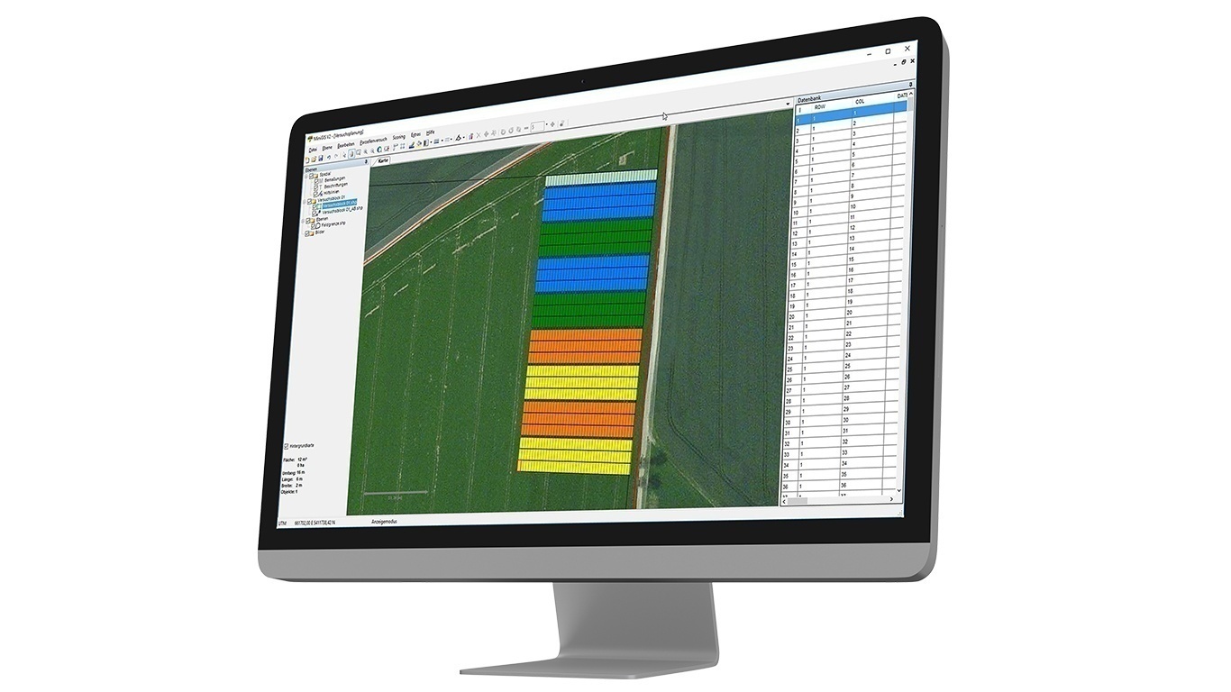
Application example: Creating buffer zones to separate experimental plots within field boundaries and individually dividing fields. Field boundaries and important points within an area can easily be placed and marked on the map. Buffer zones facilitate the digital preparation of fields when planning various experiments.
The miniGIS Basic module is a prerequisite for all other listed modules.
Mapping
- Capture, display and edit points, lines and areas
- Simultaneous recording of multiple geographic elements
- Interval recording
- Navigation function in conjunction with the surveying system in the mobile application
- Additional required module: Basic
Application example: Surveying experimental plots. Using a surveying system (optional), experimental plots can be recorded with RTK accuracy as a miniGIS project and subsequently used as a basis for experimental planning. By working within a single system, data is consistently managed in miniGIS and can be easily processed further.
Scoring
- Recording scoring values using a tablet
- Easy location of the plots in conjunction with an RTK receiver (optional)
- Automatic assignment of the assessment values to the nearest parcel
- Freely definable attributes
- Additional required module: Basic
Application example: Manual scoring of experimental plots. Experimental plots are easily located for assessment when used with an optional GNSS receiver. Attributes can be freely defined and added. After assessment, entered values are automatically assigned to the nearest positioned experimental plots in the database, eliminating the need for manual marking of the target plots.
Harvest
- Output of the plot coordinates to the yield mapping software (including Schlingmann and Haldrup Harvest Manager)
- Error-free assignment of harvest data to the respective plot using a high-precision RTK-GNSS system (optional)
- Harvest the plots in any order without a harvest plan
- Additional required module: Basic
Application example: Harvesting plots. The coordinates of individual plots can be output directly from a miniGIS experimental plan (in conjunction with an optional GNSS receiver) to the yield mapping software on the harvesting vehicle. This results in automatic assignment of the information to the harvested experimental plots. Plots can therefore be processed in any order without a harvesting plan.
Field Trial Manager
- Designing experiments with varying plot lengths and widths
- Aligning the parcels
- Import of experiments from Excel, PIAF, Wintersteiger or Schlingmann software
- Data exchange via CSV interface
- Export to steering systems
- Remote output in conjunction with Topcon and Trimble steering systems
- Export to other mobile devices, e.g. surveying systems
- Additional required module: Basic
Application example: Establishing experimental plots. Experimental plots can be digitally planned, taking field boundaries into account, and optimally positioned in the field where soil and yield maps show the least discrepancies. This planning data is then exported to guiding systems and used for automatic sowing in conjunction with tractors and seed drills.
VRC
- Division into productive and unproductive plots
- Selection of plots via integrated database
- Application maps for variable plot lengths without changing the machine
- Application maps for applying different quantities
- Implementation using a suitably prepared seed drill
- Additional required module: Basic + Field Trial Manager
Application example: Crop protection trial. Planned trial plots can be divided and marked into productive and non-productive plots. This information is exported to the steering system, and plots can be treated or left untreated accordingly using section control on the implement.
Air
- Planning and evaluating drone-based data
- Creating and aligning plot trials for the scoring of UAV flights
- Automatic or manual counting of objects in aerial images (e.g., individual plants, flowers, or ears of grain)
- Evaluation of UAV multispectral data for the relative assessment of plant biomass
- Experimental statistics: Plot-by-plot evaluation of plant heights, lodging tendency, vegetation indices and field emergence (table export as dbf and csv files)
- Automated creation of soil reference models
- Color coding of plots and a statistics tool for identifying soil trends or experimental errors.
- Index Calculator: Fast calculation and display of available indices. The index library is individually configurable according to the available sensors.
- Additional required module: Basic
Application example 1: Counting Individual Plants. Using miniGIS Air, georeferenced aerial images from drone footage can be displayed, analyzed, and processed. Depending on the application, individual plants can be counted, or the coverage of an experimental plot can be calculated.
Application example 2: Evaluating Growth Indices. Using miniGIS Air, georeferenced aerial images from drone footage can be displayed, analyzed, and processed (growth indices such as NDVI). Growth differences can be recorded on a plot-specific basis and evaluated representatively. Sowing errors can be masked and excluded from the analysis.
REQUEST NOW:
We’re happy to advise you!
+49 (0) 8424 89890

